Birding window
Great Salt Lake
Two days on a moving shoreline
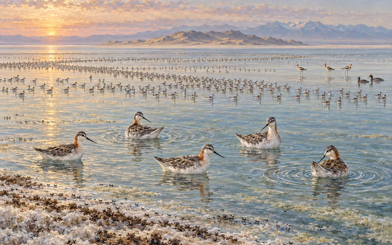
An inland sea with no outlet, a food supply of brine shrimp and brine flies, and an edge that is somewhere different every year.
Three rivers run into Great Salt Lake and nothing runs out, so what arrives stays and what evaporates leaves its salt behind. Almost nothing lives in the result except brine shrimp and brine flies, and they live in it by the ton — which is why, through the last days of July and into August, well over a hundred thousand Wilson's Phalaropes are out on the open water, moulting, spinning and doubling its weight before a nonstop flight to South America. The birds are real and the numbers are real. What moves is everything else: the water, the shoreline, the freshwater deltas and the roads that reach them. This is a plan for two days built around that, based in Ogden, with a scope.
At a glance
Planning the trip
- Give it
- Two days, and a third morning if you can spare one. The two days are not two halves of a tour — they are two different lakes. One is fresh water and delta; the other is brine. Anyone who tells you a single stop will show you Great Salt Lake has been to one of them.
- Base in
- Ogden. It sits almost exactly between the two days: about twenty-five minutes to the Antelope Island gate, half an hour to the Bear River visitor centre, and twenty minutes to the Layton shorelands. Salt Lake City works too and puts you further from Bear River; Brigham City puts you closer to it and further from everything else.
- Fly into
- Salt Lake City (SLC), about forty miles and forty-five minutes north to Ogden on I-15. It is a full hub with a wide schedule, and there is no serious alternative.
- Car
- Essential, and not merely for the driving. Both mornings involve long gravel dikes where the vehicle is the hide, the air conditioning is the only shade for miles, and the ability to leave at eleven o'clock is a safety measure rather than a preference.
- Scope
- Also essential — this is the one trip in this calendar where binoculars alone will not do. The phalaropes are on open water, often several hundred yards out and sometimes a mile, and the difference between a grey shimmer and forty thousand spinning birds is twenty times magnification on a steady tripod.
- Difficulty
- Easy underfoot and hard overhead. Everything here is flat, most of it is birded from a car or a boardwalk, and none of it involves a scramble. The difficulty is heat, glare and distance: no shade, no shelter, temperatures routinely over a hundred by early afternoon, and identification through heat shimmer at range.
- Book ahead
- Lodging in Ogden, which is straightforward in midsummer, and — before you leave home — the free digital access permit that Utah now requires of adults at Farmington Bay and most other wildlife management areas. Bear River, Antelope Island and the Layton shorelands need no permit; Antelope Island charges at the gate.
Natural history
Why this window
Great Salt Lake is what is left of Lake Bonneville, and it is a terminal sink: the Bear, the Weber and the Jordan flow in, nothing flows out, and every mineral those rivers carry stays. The water is several times the salinity of the ocean and in the north arm much saltier again, which rules out fish and almost everything else. What it does not rule out is brine shrimp and brine flies, and with no fish to eat them they occur in quantities that are difficult to describe — the flies in drifts along the salt crust, the shrimp in clouds through the upper water. This is a lake with almost no species and almost unlimited food, and for a bird that can use it, that is the best possible arrangement.
Wilson's Phalaropes finish breeding on the northern prairies early, the females leaving first, and begin arriving here from late June. They stay for weeks rather than days, because they have two jobs to do: a complete moult of the flight feathers, and enough weight gain — close to a doubling — to cross the equator. They feed by swimming in tight circles, which lifts a small vortex and brings brine shrimp within reach of the bill, and a flock doing it together is the thing people come to see. Utah's waterbird survey puts the lake-wide mean at about 126,000 birds across June to August, with a survey peak of 171,876 on 10 July and a record of 354,729 in 2000, against a world population of roughly a million and a half.
Read those numbers carefully, because they are the reason this page is arranged the way it is. They are lake-wide totals assembled from forty-four survey areas, most of which have no road, no dike and no legal access. The lake is not one habitat but four that move independently — open brine, freshwater delta, managed impoundment and bare salt flat — and the birds follow whichever is producing. Bird the interfaces, not the lake. A visitor standing at one accessible shore on one morning may be looking at a genuinely huge flock or at empty water three miles out, and both are normal.
The plan
Two days, two different lakes
The order barely matters; the hour does. Both days are built to be finished by noon, because from late morning the light goes flat, the heat shimmer makes a scope useless at range, and standing in it stops being sensible. Check the Bear River road report and the Antelope Island conditions page the evening before, and swap the days if either has gone wrong.
The freshwater day
Bear River, from first light to the heat
The delta end of the system: the Bear River spreading into managed impoundments before it reaches the brine. This is where the numbers are close enough to count, and where almost everything that is not a phalarope lives.
-
Sunrise −45 minTravel
Out past the visitor centre, and keep going
This catches people out every year. The Wildlife Education Center sits just off I-15 at Brigham City, but the auto tour route does not start there — it begins a further twelve miles west, out West Forest Street, across farmland that turns to marsh and then to nothing much at all. The whole errand is thirty-six miles round trip from the interstate. Leave Ogden about three-quarters of an hour before sunrise; sunrise runs from about ten past six to half past six across this window.
-
SunriseDawn
The auto tour, one way round
Twelve miles of gravel dike, one-way and counter-clockwise, free, open sunrise to sunset with a gate that shuts at dusk. Drive it slowly with the windows down and the engine off at the pull-offs. The car is a far better hide than you are: White-faced Ibis, avocets and stilts feed within yards of the road, and stepping out usually ends that.
-
08:00Daylight
Round again, and slower
The impoundments are managed at different levels and hold different birds from one unit to the next, so the second half of the loop is rarely the same as the first, and a second circuit is often better than the first. Work the edges where a unit has been drawn down: that is where the godwits and dowitchers are, and where a scope pays for itself.
-
10:00Break
Off the dike before the heat closes it down
There is no shade anywhere on the loop and no water but what you brought. By mid-morning the shimmer starts lifting off the gravel and anything at distance dissolves. Drive out, and use the visitor centre at Brigham City for the air conditioning, the current water report and the view over the spur from the deck.
-
19:30Dusk
Back out, if the day has cooled
The last two hours are the other half of this loop and almost nobody takes them. The light comes from behind you on the westward leg, the ibis flight lines cross the dikes, and the heat has gone out of the air. Watch the clock against the dusk gate closure rather than against sunset, which is not until nearly nine.
The saline day
Antelope Island at opening, then whichever bay still has water
The brine end: open saline water, salt crust and brine flies, and the phalaropes. Antelope Island is the only place on this list where you can stand beside the open lake, which is why it is worth being at the gate when it opens rather than an hour later.
-
06:00Dawn
The causeway, at the gate
The park opens at six and the causeway runs seven miles out to the island — over water, or over what was water a few years ago, depending on the year. Stop at the pull-offs rather than driving it — this is the stretch where phalaropes, avocets and gulls come closest to a road anywhere on the lake, and where the brine-fly drifts are thick enough to hear. Set the scope up on the north side while the sun is behind you.
-
07:30Daylight
The island's north end and Bridger Bay
Round the north end for the open water of Gilbert Bay, which is where the big rafts sit when they are sitting anywhere. Scan out rather than along; a distant line of grey that resolves into spinning birds is the whole point of the morning. Give the bison the distance the park asks for and then double it — late July is the rut, and the bulls are not ornamental.
-
09:30Daylight
Down the east side, facing Farmington Bay
The road to the Fielding Garr Ranch runs the length of the island's east shore with Farmington Bay on your left — fresher water, a different set of birds, and a useful comparison to make in the same hour as the brine. This is also the best chance on the island of Snowy Plover on the flats, which is a matter of luck rather than of effort.
-
11:30Break
Off the island
There is effectively no shade on Antelope Island and the afternoon is not worth having. Take the causeway back, note what the water was doing on the way out, and spend the middle of the day indoors.
-
18:00Dusk
Layton or Farmington, depending on the water
Two options and the choice is made by current conditions rather than by preference. The Great Salt Lake Shorelands Preserve at Layton is a mile of boardwalk over freshwater marsh, free, open until nine, and needs no permit. Farmington Bay is bigger, wilder and better when the impoundments are up, but the dikes are seasonally restricted and adults need the state's permit or a licence — except at the Eccles Wildlife Education Center, which is specifically exempt. If you have not sorted the permit, go to Layton.
Ground
Where to bird
Four places, all of them genuinely public, all within forty minutes of Ogden. They are chosen because between them they cover the four interfaces — delta, open brine, managed impoundment and freshwater marsh — and because their access can actually be verified. Plenty of famous names around this lake are on private land, behind a locked dike, or reachable only by a road that a passenger car should not attempt.
-
01
Bear River Migratory Bird Refuge
Auto tour, twelve miles west of the visitor centre, Brigham City
Free · auto tour, daylight hours Sunrise to mid-morning, and the last two hours
Nearly eighty thousand acres where the Bear River spreads out before it reaches the brine, and the single best concentration of accessible birds in the basin. A twelve-mile one-way gravel loop runs the impoundments, with pull-offs throughout; it is free and open sunrise to sunset, with a security gate that closes at dusk. The loop begins twelve miles west of the Wildlife Education Center, which is the part people get wrong — budget thirty-six miles round trip from I-15. Road conditions govern everything out here: the route closes for weather and for repairs, and the refuge posts the current state before it posts anything else.
-
02
Antelope Island State Park
Causeway from Syracuse · the island's north end and east road
$15 a vehicle · gate 6 a.m. The gate at six, until about ten
The only place on this list where you can stand beside open saline water, and therefore the only place where the phalaropes are a spectacle rather than a rumour. A seven-mile causeway crosses to a fifteen-mile island of grassland and rock; the park is open six in the morning to ten at night, fifteen dollars a vehicle. Egg Island and White Rock are closed year-round for nesting birds. Check the park's conditions page before you set out — the visitor centre has recently been shut for renovation, the marina ramp is out with the low water, and both are the kind of thing that changes without notice.
-
03
Farmington Bay WMA
Glover Lane, Farmington · Eccles Wildlife Education Center
Free permit or Utah licence Evening, and only with the access sorted first
The largest piece of managed freshwater marsh on the east shore and, when the units are up, the best of the four. It is also the one with conditions attached. Since 1 July 2026 anyone eighteen or over needs either a free digital access permit — obtained online after a short video — or a Utah hunting, fishing or combination licence to enter this and most other wildlife management areas; the state's own list makes the exception plain, in that neither is required at the Eccles Wildlife Education Center or the Hasenyager Reserve. The dike roads are separately gated and seasonally restricted through the nesting season, and the gates do not open at dawn. Sort both before you drive out.
-
04
Great Salt Lake Shorelands Preserve
3200 West, Layton · I-15 exits 330 or 331
Free · 6 a.m. to 9 p.m. Early morning or the last hours before nine
A mile of boardwalk laid over freshwater marsh, mudflat and salt marsh, with a thirty-foot observation tower at the end of it, run by the Nature Conservancy and open to anyone from six in the morning until nine at night between March and October. No fee and no permit. It is the reliable option on the east shore: shorter than Farmington Bay, less dramatic, and never closed for a gate or a season. Avocets, stilts and White-faced Ibis are the staples. Stay on the boardwalk, and leave the dog at home — pets are not allowed.
The list
What to look for
The honest position is this. Wilson's Phalarope in July is as close to a certainty as this calendar offers, because the birds are here for weeks and there are hundreds of thousands of them. Whether you see a hundred or forty thousand depends on where the water is and which shore you are standing on. Everything else below is a matter of the interface and the hour, and the three at the end are matters of the date.
What the window is built on
- Wilson's Phalarope Phalaropus tricolor
- The reason for the trip. Moulting adults on open brine, spinning in tight circles to raise shrimp within reach of the bill. Look for a grey shimmer resolving into movement rather than for individual birds; a scope turns one into the other.
- American Avocet Recurvirostra americana
- Nearly as numerous as the phalaropes and far easier to see — the survey's July-to-September mean is about 94,000 lake-wide, peaking on 10 August. They work the impoundment edges at Bear River within a car's length of the dike.
- Black-necked Stilt Himantopus mexicanus
- Everywhere on fresh and brackish water, and the loudest bird on any dike. If a stilt starts yelling at you from a hundred yards out, you are near a late brood and should keep moving.
- White-faced Ibis Plegadis chihi
- The bird that gives the Bear River impoundments their shape at first and last light, crossing the dikes in loose lines. In low sun the bronze and green come up out of what otherwise looks like a black bird.
- California Gull Larus californicus
- The lake's own gull, nesting on its islands in tens of thousands and then dispersing across every shoreline and flat. Worth learning properly here, because it is the default against which anything else is judged.
- Western Grebe Aechmophorus occidentalis
- On the fresher bays and the deeper impoundments rather than out on the brine. Long, low and improbable in a scope at range; in late July there are still young riding on backs.
Worth the right water and the right hour
- Marbled Godwit Limosa fedoa
- Autumn passage is already under way by late July. Drawn-down impoundment edges at Bear River are the place, usually in small parties working a mudline that was underwater a fortnight ago.
- Long-billed Dowitcher Limnodromus scolopaceus
- Same ground as the godwits and the same timing, feeding with the sewing-machine action that identifies the genus from half a mile before anything else does. Short-billed is genuinely scarce here, so the easy answer is usually the right one — but listen anyway.
- Clark's Grebe Aechmophorus clarkii
- Alongside Western Grebe and worth separating: the black cap stopping above the eye, the brighter bill. Mixed pairs occur, so expect birds you cannot call, and be content with that.
- American White Pelican Pelecanus erythrorhynchos
- Breeding on Gunnison Island out in the north arm, where nobody may go, and commuting thirty miles and more to fresh water to feed. A line of them over Bear River is a bird at the far end of its working day.
- Willet Tringa semipalmata
- The western breeding birds are all around the lake's wetlands and are already beginning to move by this window. Plain and grey on the ground, and then unmistakable the moment they open a wing.
Timing, not promises
- Red-necked Phalarope Phalaropus lobatus
- Present in this window but not yet in force: the coordinated counts put the peak at the turn of August into September, when Great Salt Lake has held over forty thousand in a single survey period. In late July, expect to pick a few out of the Wilson's rather than to find flocks of them.
- Snowy Plover Charadrius nivosus
- The number that ought to calibrate expectations: the lake-wide mean across the whole season is about 363 birds and the survey peak is 621, spread over forty-four survey areas and hundreds of miles of salt flat. They are genuinely here and you may well not see one.
- Eared Grebe Podiceps nigricollis
- The rafts that photographs are made of belong to late August, September and October — the survey mean for August and September is around 93,000 and the record is close to 700,000. In late July the birds are arriving rather than assembled. Take what is there and do not measure it against the pictures.
Practical
Know before you go
The water moves, and so do the birds
This is the first thing to check and the thing that governs everything else. The USGS gauges the lake continuously: the south arm at Saltair stood at about 4,190 feet in September 2026, against a record low of 4,188.5 feet in November 2022 and a high of 4,211.6 feet in June 1986. Twenty-two feet of range on a lake this shallow moves the shoreline by miles and relocates every feeding flock with it. Look at the current gauge reading and the refuge and park conditions pages in the week before you travel, and again the night before.
Never walk out toward the water
The exposed lakebed looks like a firm white beach and is not. Under the salt crust is metres of soft, saturated mud that will take a boot and keep it, and the distances are deceiving — what appears to be a few hundred yards of flat to the water's edge is routinely a mile or more with nothing to navigate by. There is no shade, no landmark and no cover, and the birds are better seen through a scope from a road anyway. Stay on the boardwalks, the dikes and the causeways. This is not caution; it is the single way people get into serious trouble here.
Heat, and the hours that work
Late July in the Salt Lake valley is routinely in the high nineties and frequently over a hundred Fahrenheit, with no shade at any site on this page. Sunrise runs from about ten past six to half past six through the window and sunset is near nine, so the usable hours are early and late and the middle of the day is for being indoors. Carry more water than you think — a gallon a person is not excessive on a dike — plus sun cover, and treat the car's air conditioning as part of the equipment. Check the National Weather Service forecast for Salt Lake City, which issues the heat risk products for the valley.
Glare, shimmer and when the scope stops working
Salt water, salt crust and a white lakebed make this one of the brightest places you will bird, and the glare comes from below as well as above. Polarised sunglasses help more than they usually do. Heat shimmer is the real constraint: from mid-morning a scope at forty times becomes useless past a few hundred yards, which is precisely when most of the phalaropes are out of reach. Work distance early, and keep the low-magnification eyepiece for later. Wildfire smoke is a genuine possibility in a Utah summer and does the same thing to visibility with none of the warning.
The permit at Farmington Bay
Since 1 July 2026 Utah has required anyone eighteen or older to hold either a free digital access permit or a valid Utah hunting, fishing or combination licence to enter most wildlife management areas in Davis, Salt Lake, Utah and Weber counties — Farmington Bay and Ogden Bay among them. The permit costs nothing and is obtained online after a short educational video, but it is not something to discover at a gate. The state's own list names the exception: it is not required at the Eccles Wildlife Education Center or the Hasenyager Reserve. Bear River is federal and needs no permit; Antelope Island is a state park and charges at the gate instead.
Antelope Island: gate, fee, bison and flies
The park is open six in the morning until ten at night and charges fifteen dollars a vehicle, ten for seniors, three on foot or by bicycle; an annual state-parks pass does not cover the county's separate causeway charge. Bison roam free and late July is the rut: the park's own biologist puts the minimum at twenty-five yards and advises seventy-five to a hundred, and a bull that has noticed you is already too close. The insects are not what people expect. The biting gnats are an April-to-June problem and largely over; mosquitoes persist and repellent works on them; the brine flies that carpet the shoreline in midsummer neither bite nor land on you, and the midge columns along the causeway are food rather than a nuisance.
Roads, gates and the things that close
Bear River's auto tour is a gravel dike subject to weather, flooding and repair closures, and it has a security gate that shuts at dusk rather than at sunset. Farmington Bay's dike roads are gated and seasonally restricted through the nesting season, and the gates do not open at first light. Antelope Island's causeway, marina and visitor centre have each been affected in recent years by low water or by construction. Every one of these is posted by the agency that owns it, and none of them is posted anywhere else reliably. Ring or read before you drive.
Storms, and what a Utah afternoon can do
Midsummer here is not uniformly clear. Monsoonal moisture reaches northern Utah through late July and August and produces afternoon thunderstorms that build fast over the Wasatch and move out over the lake, and a dike road in the middle of an impoundment is the most exposed place for miles. Outflow winds ahead of a cell can also raise dust off the exposed lakebed and shut visibility down in minutes. If the sky over the mountains starts stacking up in the early afternoon, that is the day's signal to be finished.
Sources
Lake level, road conditions, gate hours, fees and the state's access rules all change, and several of them changed recently. These are the bodies that manage the ground and publish the current position; check them in the week before you travel rather than trusting this page.
- Utah DWR — Great Salt Lake Ecosystem Program
- Utah DWR — Great Salt Lake waterbird survey: Wilson's Phalarope
- Utah DWR — wildlife management area access rules and permit
- Utah DWR — Eccles Wildlife Education Center
- U.S. Fish & Wildlife Service — Bear River auto tour
- Antelope Island State Park
- Antelope Island State Park — current conditions
- The Nature Conservancy — Great Salt Lake Shorelands Preserve
- USGS — Great Salt Lake at Saltair Boat Harbor, current elevation
- National Weather Service — Salt Lake City forecast office
Last reviewed 21 September 2026